

- Visiting Iceland
- Travel Information
- FAQ
- Protected Areas
- Westfjords
- Breidafjordur
- Dynjandi in Arnarfjordur
- About the area
- Access and services
- Pay for parking
- Nature
- Culture and history
- Drone use at Dynjandi
 Dynjandi in Arnarfjordur
 - Flatey in Breidafjordur
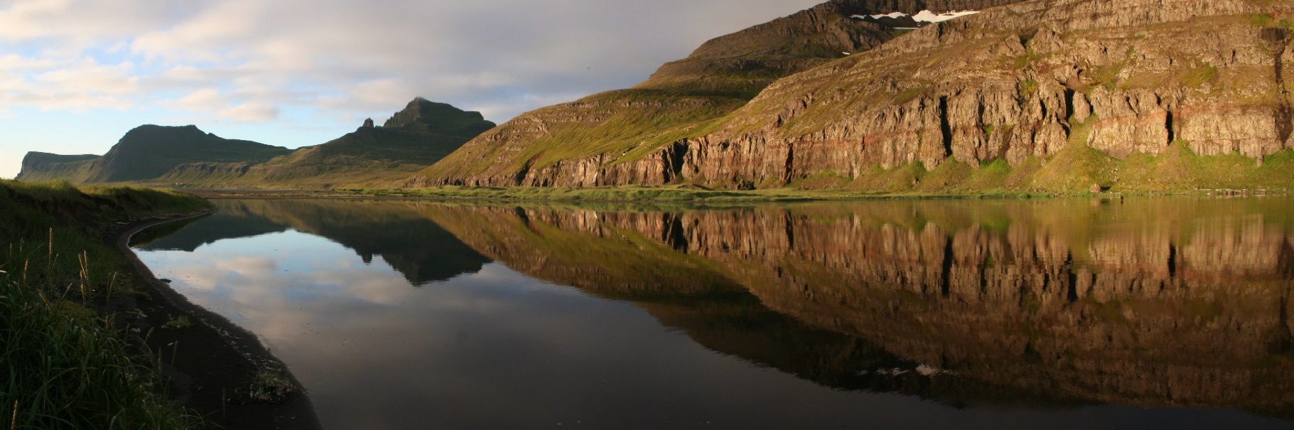
- Hornstrandir
- Hrisey, Reykholahreppur
- Látrabjarg
- For seafarers
Látrabjarg - Surtarbrandsgil
- Vatnsfjordur
Westfjords - North West
- North East
- Boggvistadafjall
- Dettifoss and a row of waterfalls
- Dimmuborgir
- Public park in Glerardalur
- Reservation in Svarfadardalur
- Godafoss in Thingeyjarsveit
- Hraun in Oxnadalur
- Hverastrytur in Eyjafjordur
- Hverfjall
- Krossanesborgir
- Myvatn and Laxa
- Seljahjallagil
- Skutustadagigar
- Vatnajokull National Park
- Vestmannsvatn
North East - West
- Andakill
- Bardarlaug, Snaefellsbaer
- Blautos and Innstavogsnes
- Breidafjordur
- Budahraun
- Einkunnir, Borgarbyggd
- Eldborg in Hnappadalur
- Geitland, Borgarbyggd
- Grabrokargigar, Borgarbyggd
- Grunnafjordur
- Hraunfossar, Borgarbyggd
- Husafellsskogur, Borgarbyggd
- Kalmanshellir
- Melrakkaey
- Stedji (Staupasteinn)
- The coast by Stapi and Hellnir
- Vatnshornsskogur, Skorradalur
- Snaefellsjokull National Park
West - Search by name
- East
- South West
- Akurey
- Alafoss, Mosfellsbaer
- Astjorn, Hafnarfjordur
- Astjorn and Asfjall, Hafnarfjordur
- Bakkatjorn, Seltjarnarnes
- Blafjoll Public Park
- Borgir, Kopavogur
- Bringur, Mosfellsdalur
- Burfell, Gardabaer
- Eldborg in Blafjoll
- Eldborg in Geitahlid
- Eldey, Reykjanesbaer
- The shore by Kasthusatjorn
- Fossvogsbakkar, Reykjavik
- Gardahraun, Gardabaer
- Galgahraun, Gardabaer
- Grotta, Seltjarnarnes
- Hamarinn, Hafnarfjordur
- Haubakkar, Reykjavik
- Hleinar, Hafnarfjordur
- Hlid, Alftanes
- Hvaleyrarlon and Hvaleyrarhofdi
- Kaldarhraun and Gjarnar
- Kasthusatjorn, Alftanes
- Laugaras, Reykjavik
- Litluborgir, Hafnarfjordur
- Raudholar, Reykjavik
- Reykjanes Public Park
- Skerjafjordur, Gardabaer
- Skerjafjordur, Kopavogur
- Stekkjarhraun, Hafnarfjordur
- Trollaborn, Lækjarbotnar
- Tungufoss, Mosfellsbaer
- Valhusahaed, Seltjarnarnes
- Varmarosar, Mosfellsbaer
- Vifilsstadavatn, Gardabaer
- Vigholar, Kopavogur
South West - South
- Alftaversgigar
- Arnahellir in Leitahraun
- Dverghamrar
- Dyrholaey
- Fjallabak Nature Reserve
- Geysir Area
- Gullfoss
- Herdisarvik
- Jorundur in Lambahraun
- Kerlingarfjoll
- Kirkjugolf
- Oddaflod
- Pollengi and Tunguey
- Skogafoss
- Surtsey
- Area in Thjorsardalur
- Vatnajokull National Park
- Videy in Thjorsa
- Thingvellir National Park
- Thjorsarver
South - Mývatn and Laxá
- National Parks
Protected Areas - Westfjords
- Permits in protected areas
- Operational licence
- Photography, cinematography and drone flying
- Research permit
Permits in protected areas - Drones in protected areas
- Guidelines for using drones in protected areas
- Flights in protected areas
- Apply for permit
Drones in protected areas - Volunteers
- Snæfellsjökull National Park
Visiting Iceland - Wildlife
- Air & Climate
- Ocean & Water
- Industry
- Chemicals
- Frequently asked questions
- Biocides
- Classification and labelling – CLP
- Cosmetics
- Detergents
- Fluorinated greenhouse gases (F-gases)
- Fuel
- Certificate for pest control
- Certificate for professional use of plant protection products
- Plant protection products
- POPs
- REACH
- Safety data sheets
- Supervision, inspection and coercive measures
Frequently asked questions - Biocides
- Classification and labelling
- CLP
- Classification
- Labelling
- Packaging and retention
Classification and labelling - Cosmetics
- Detergents
- F-gases
- Fuel
- Plant protection products
- Authorisation
- Harmonised Risk Indicators
Plant protection products - POPs
- REACH
- Fees
Chemicals - Frequently asked questions
- Importation of Alien Species
- ETS
Industry - Chemicals
- Circular Economy
- Waste
- Waste Management
Circular Economy - The Agency
Vinna við nýjar heimasíður Umhverfis- og orkustofnunar og Náttúruverndarstofnunar er í gangi. Heimasíða Umhverfisstofnunar er virk á meðan vinnunni stendur. Information in English
.svg)
Hiking trails
Hornstrandir nature reserve offers many hiking trails, some are quite easy but others more challenging. As the area is remote, all hikers are expected to be well-equipped and prepared before going on a hike in Hornstrandir.
Hesteyri – Aðalvík in Sæból, through Sléttuheiði (12 km 6 hours)
From Hesteyri the path out of Hesteyrarfjörður goes up to the mountain Nóngilsfjall. Follow the path into Sléttuheiði (280 m). The path is marked with cairns and most of the way is visible. The river Sléttuá needs to be crossed just above Slétta. When walking down the valley Fannadalur towards the church at Staður, the path can be wet and occasionally not easily visible. If you decide to walk to Slétta, 1-2 hours should be added to the hiking time. .jpg)
Hesteyri
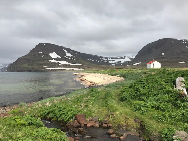
Sæból in Aðalvík
Sæból – Darri – Sæból (7 km 3 hours)
From the camp site in Sæból, Aðalvík, there is a path that will lead you to the river Traðará. On the other side of the river, there is a well visible path that takes you up to the valley Garðadalur. After crossing the river, keep following the path all the way up the mountain. On top of the mountain, there is a road that will lead you to the ruins of the British military base on mountain Darri (490 m).


Remains from the British military base on mountain Darri
Hesteyri – Látrar in Aðalvík, through Hesteyrarskarð (10 km 4 hours)
The path from Hesteyri village up to the pass Hesteyrarskarð (270 m) is an old but easily visible road. From the pass to Stakkadalur the path lies in a little distance from the cairns that mark the way. When coming down to Stakkadalur, cross the river Stakkadalsós. The bottom of the river is mostly sand. After crossing the river, a path will lead you to the campsite at Látrar.

Hesteyrarskarð (270m) view towards Látrar
Látrar – Straumnesfjall – Rekavík – Látrar (22 km 6-8 hours)
The path from Látrar up to the mountain Straumnesfjall goes from the dock further inland, along the mountain Látrafjall. Follow the road up the mountain all the way up to the ruins of the old US military base. The way down from Straumnesfjall leads towards Öldudalur valley in Rekavík. There is no visible path here, but occasionally you can see cairns or pieces of cairns. It is possible to walk down to the old farmhouse in Rekavík and then hike along the lake towards Látrar. It is recommended to keep a little altitude and stay above the cliff wall, around 60-80 m, when hiking towards the river Grasadalsá in Rekavík. On the other side of the river Grasadalsá, there is a well visible road that will take you back to Látrar.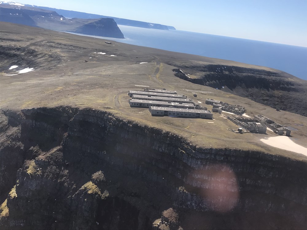
The ruins of the old US military base
Látrar – Fljótavík, through Tunguheiði (10 km 4-5 hours)
From Látrar, the path will lead you east alongside the mountain Látrafjall. The path turns west just above Rekavík. Just before the main path goes up to the mountain Straumnesfjall, you will see a hiking path marked with cairns that leads east towards Tunguheiði (480 m). The path down to Tungudalur is steep. You pass the farm Tunga and from there you should walk a little bit inwards on your way to the lake. The ford by lake Fljótavatn is marked, opposite to Langanes (the Long point). Keep in mind that the water can be as high as up to your groin.
Tunguheiði - looking towards Aðalvík
Fljótavík – Kjaransvík, through Þorleifsskarð (15 km 7-8 hours)
The path leads through moorland along lake Fljótavatn. Hike up the valley Þorleifsdalur and from there up the steep slopes of the pass Þorleifsskarð (360 m). The hiking path down from the edge of Þorleifsskarð and down to Almenningar goes through steep rockslides and boulders. The boulders continue through Almenningaskarð (430 m) down to Kjaransvík. This is a difficult hike and a slow journey. Part of the way is marked with sticks, but nevertheless, it is easy to lose one’s way in a fog. From Kjaransvík, it is a short hike is by the shore to the campsite in Hlöðuvík.
Hesteyri – Kjaransvík – Hlöðuvík, through Kjaransvíkurskarð (14 km 6-7 hours)
The path from the village Hesteyri to Hlöðuvík is well marked with cairns. From Hesteyri, the path leads you up to the mountain shoulder of Hesteyrarbrúnir and to the pass of Kjaransvíkurskarð (426 m). The path is marked with cairns down the valley from the pass to the shore of Hlöðuvík. The river Kjaransvíkurá is crossed at the shore. Continue the hike east along the shore and after you pass the mountain Álsfell, you will find yourself at the campsite in Hlöðuvík. 
Hesteyri - view from Hesteyrarbrúnir
Hlöðuvík – Hornvík, through Atlaskarð (10 km 4-5 hours)
From Hlöðuvík the walking route goes past Búðir farm. The path goes up on the north side of Skálakambur ridge (350 m). The trail is narrow and quite steep but marked. The way over to the Atlaskarð pass is well marked with cairns. The slopes take you along the valley of Hælavík, over Atlaskarð (327 m) and down to Rekavík. There is a well visible path all the way down to the shore, where you pass the river Rekavíkurá and follow the path over the cliff Tröllakambur and to the campsite in Höfn. 
Hlöðuvík view from Skálakambur. Majestic Álfsfell in the background

Rekavík
Veiðileysufjörður – Hornvík, through Hafnarskarð (10 km 4 - 5 hours)
From the bottom of the fjord Veiðileysufjörður, the path leads you up to Hafnarskarð. The path is well marked with cairns as it lies uphill along the river Veiðileysuá. The Hafnarskarð pass (519 m) is steep and may be covered with snow long into the summer. The path down to Höfn in Hornvík is well marked with cairns. There are many water streams on this path that might become too big to jump over in wet conditions.
 Veiðileysufjörður - view from campsite
Hafnarskarð - a large amount of snow can accumulate on both sides of the Hafnarskarð
Hrafnfjörður – Furufjörður, through Skorarheiði (7 km 3 hours)
The path leads from the bottom of the fjord Hrafnfjörður up to the mountain road Skorarheidi (200 m) to Furufjörður. The path takes you up on the west side of the river Skorará for approx. 1 km. There, you will find a bridge to cross the river. A well visible path leads you up to the heath, past the lake Skorarvatn. The path splits 1 km after you pass the lake. It is recommended that you leave the main path and walk along the northern hill of Furufjörður to avoid the wetland.

Gýgjarsporshamar in the bottom of Hrafnfjörð

The bridge over Skorará in Hrafnfjörð

The path between Skorarheiði and Furufjörð

The prayerhouse in Furufjörð
Furufjörður – Hornvík (2-3 days)
The way to Hornvík goes along the northern shore of Furufjörður. It is only possible to pass Bolungarvíkurófæra during low tide. From Bolungarvík, the path takes you over the pass Göngumannaskörð (366 m) in to Barðsvík and from Barðsvík over to Smiðjuvík via Smiðjuvíkurháls along Almenningar towards mountain Axarfjall. Most of the paths on this trail are not marked.
From mountain Axarfjall, the path leads down to Hornbjargsviti lighthouse in Látravík. You could also hike straight to Hornvík, then you maintain the height of Axarfjall and walk west towards the pass Kýrskarð (315 m) and down to Hornvík.
From Furufjörður it is also possible to walk south over the pass Svartaskarð (393 m) towards Þarlátursfjörður and Reykjafjörður, Ófeigsfjörður and Ingólfsfjörður (4-5 days).
.jpg?proc=frett1000)
The overview of Smiðjuvík

Smiðjuvík
Bjarnanes

The view from Hrollaugsvík - Bjarnanes
Höfn in Hornvík – Hornbjarg cliff (13 km 8-10 hours)
From the camp site in Höfn, Hornvík, go towards the river Hafnarós. The wade over Hafnarós is just opposite to the river Kýrá. The walking path leads along the river to shore and then along the beach east towards Horn (238 m) in Ystidalur. From Horn it is possible to walk in a circle around the cliff and over the mountain Miðfell (366 m). Please keep in mind that the path over Miðfell is steep and can be difficult to walk, especially in wet weather.

Hornbjarg, view from Höfn

Mist over Miðfell

Svaðaskarð, just beneath Miðfell
Hornbjarg – Innstidalur – Hornbjargsviti, lighthouse
The path leads up the valley Innstidalur. It begins by the farmhouses at Horn and takes you up to Almenningaskarð (310 m). From the path you can either walk by the edge of the cliff and towards Kálfatindar or you can walk towards the lighthouse Hornbjargsviti. From the lighthouse it is possible to walk directly up to the pass Kýrskarð (326 m) and from there back to Hornvík.

Almenningsskarð - view to the east